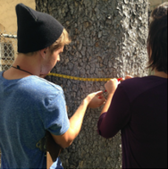
 By Myles Ritchie Program Intern “What is ground-truthing? The easiest response is that ground-truthing is physically going to the desired object (in this case an Exceptional Tree) and obtaining the data in person that confirms previously collected data, or generates primary data that has never been collected for the specific target. The Outdoor Circle began its initial tree mapping process with two graduate students from the University of Hawaii at Manoa, Nate and Spencer. The two of them worked together to complete Phase One of the project, which involved inputting previously collected data about Hawaii's Exceptional Trees into an open-source program called “Google Fusion”. Phase Two, which we are currently in, involves verifying or "ground trotting" all of the data inputted during Phase One. Much of the data is outdated. The Exceptional Tree Act was enacted in 1975 and counties have had varying success maintaining their paper records of protected trees. The results have been typical of what is to be expected with data collected long ago: removed/dead trees, inaccurate coordinates, etc.. This just further demonstrates the importance of the ground-truthing process is when it comes to generating an accurate map for the public to use. Ground-truthing requires a GPS unit, a tree-height finder, and an industrial tape measure to get the circumference of the tree. It is faster to ground-truth trees with another person and it provides a second opinion. A second opinion is important when assessing the condition of a tree, and deciding which new trees should be potential nominees. Also, the average park-goer might be curious and want to ask questions. By having a second person, the ground-truthing tasks can still be carried-out by one individual (although slower), while the other does the equally important task of educating the public on our goals for this project. As a side-note, by having two or more individuals mapping, it also makes the process safer and a lot more fun! On March 4, I (along with three other incredible OC members) went to Hawaii Island to collect data for the map, and I am proud to say that Phase Two for the entire island was completed. Furthermore, I would like to say mahalo to our #GIVINGTUESDAY donors. Your donations helped pay for an experience that I will use in my future career as an environmental impact researcher, which will involve documenting and mapping the various ways humans impact the environment. From this, the goal of implementing positive changes to current policies and practices regarding environmental conservation is something I am extremely passionate about and look forward to accomplishing. About the Author: Myles serves as Programs Intern for The Outdoor Circle. He received his bachelor’s degree in Environmental Geography along with minor degrees in geology/geophysics and history. He is studying for his master's degree at UH-Manoa in Geography. He is from Toronto, Canada. Comments are closed.
|
Welina!The Greenleaf is the online newsletter and blog of The Outdoor Circle. Here you will find updates on the projects and accomplishments of our many branches throughout the state, as well as programs with statewide impact. Archives
September 2023
Categories
All
|

 RSS Feed